area we cover
~ KEIGHLEY ~ |
|---|
"KEIGHLEY, a market and parish-town, in the east-division of Staincliffe, liberty of Clifford's-Fee; 4 miles from Bingley, 10 from Bradford and Skipton, 12 from Otley and Halifax, 12¾ from Colne, (Lanc.) 40 from York, 209 from London. Market, Wednesday. Fairs, May 8, for horned cattle and horses; 9 and 10, for pedlary ware, November 7, for horned cattle, horses, and sheep; and 8 and 9, for pedlary ware. Principal Inns, Devonshire Arms, and Kings Arms. Pop. 9,223. The Church is a rectory; dedicated to St. Andrew, in the deanry of Craven, value, £21. 0s. 7½d. Patron, the Duke of Devonshire." This is a considerable market-town, at the north western extremity of the manufacturing district. It is situated in a deep valley, within three or four hundred yards of the South west bank of the river Aire, over which there is a stone bridge. The town is tolerably well built, almost wholly of stone, the inhabitants of which derive their support from the cotton, linen, and worsted manufactures, which are carried on here with great spirit and industry. The manufacture of worsted may be considered as the staple trade of Keighley; large quantities of which are sold at, Bradford and Halifax. The purchasers are chiefly Leeds merchants. The town is supplied with water from two springs, under the regulations of an Act of parliament, obtained in 1816.
Provided with permission of the copyright holder, Colin Hinson. |
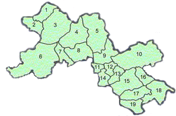
1. Ingleton |
10. Skipton |
Figure 1.
|
| The above links are to further information on GENUKI | ||
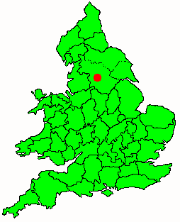
Figure 2 shows the Societies' location within
|
Figure 2. |
|